Geolocate

Kingswood topographic map

Interactive map

Click on the map to display elevation.

About this map

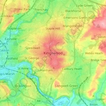
Name: Kingswood topographic map, elevation, terrain.

Location: Kingswood, South Gloucestershire, West of England, England, BS15 8LQ, United Kingdom (51.42274 -2.54839 51.50274 -2.46839)

Average elevation: 57 m

Minimum elevation: 5 m

Maximum elevation: 131 m

Other topographic maps

Click on a map to view its topography, its elevation and its terrain.

Sodbury

United Kingdom > England > South Gloucestershire

Average elevation: 122 m

Aust

United Kingdom > England > South Gloucestershire

Average elevation: 9 m

Horton

United Kingdom > England > South Gloucestershire

Average elevation: 132 m

Bitton

United Kingdom > England > South Gloucestershire

Average elevation: 83 m

Doynton

United Kingdom > England > South Gloucestershire

Average elevation: 129 m

Siston

United Kingdom > England > South Gloucestershire

Average elevation: 80 m

Yate

United Kingdom > England > South Gloucestershire

Average elevation: 83 m

Pucklechurch

United Kingdom > England > South Gloucestershire

The land of Pucklechurch is relatively prominent in elevation compared to surrounding areas and as such it was selected in the Bronze Age as the site of a tumulus (round barrow) at Shortwood Hill.

Average elevation: 98 m

Filton

United Kingdom > England > South Gloucestershire

Average elevation: 67 m

Hanham

United Kingdom > England > South Gloucestershire

Average elevation: 71 m