
Make a donation
Pray Lake topographic map
Click on the map to display elevation.
Make a donation
About this map
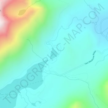
Name: Pray Lake topographic map, elevation, terrain.
Location: Pray Lake, Glacier County, Montana, United States (48.48916 -113.36698 48.49154 -113.36420)
Average elevation: 1,717 m
Minimum elevation: 1,497 m
Maximum elevation: 2,569 m
Make a donation
Other topographic maps
Click on a map to view its topography, its elevation and its terrain.
Make a donation
Make a donation
Mount Cleveland
United States > Montana > Glacier County
While not of great absolute elevation (the mountain is more than 2,300 ft (700 m) lower than Granite Peak, the highest peak in Montana), Mount Cleveland is notable for its large, steep rise above local terrain. For example, its west flank rises over 5,500 ft (1,700 m) in less than 2 mi (3.2 km); the northwest…
Average elevation: 2,339 m
Make a donation
Make a donation
Chapman Peak
United States > Montana > Glacier County
Chapman Peak (9,411 feet (2,868 m)) is located in the Livingston Range, Glacier National Park in the U.S. state of Montana. Chapman Peak is situated along the Continental Divide. The mountain is named for Robert H. Chapman, one of the US Geological Survey topographers who worked on mapping Glacier Park between…
Average elevation: 2,175 m