
Beccaud topographic map
Interactive map
Click on the map to display elevation.
About this map
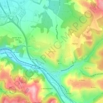
Name: Beccaud topographic map, elevation, terrain.
Average elevation: 468 m
Minimum elevation: 388 m
Maximum elevation: 580 m
Other topographic maps
Click on a map to view its topography, its elevation and its terrain.
Monteux
France > Auvergne-Rhône-Alpes > Loire > La Fouillouse
Monteux, La Fouillouse, Saint-Étienne, Loire, Auvergne-Rhône-Alpes, France métropolitaine, 42480, France
Average elevation: 493 m
Les Perrotins
France > Auvergne-Rhône-Alpes > Loire > La Fouillouse > Les Perrotins
Les Perrotins, La Fouillouse, Saint-Étienne, Loire, Auvergne-Rhône-Alpes, France métropolitaine, 42480, France
Average elevation: 451 m
Le Soleil
France > Auvergne-Rhône-Alpes > Loire > La Fouillouse
Le Soleil, La Fouillouse, Saint-Étienne, Loire, Auvergne-Rhône-Alpes, France métropolitaine, 42480, France
Average elevation: 491 m