
Nieul topographic map
Interactive map
Click on the map to display elevation.
About this map
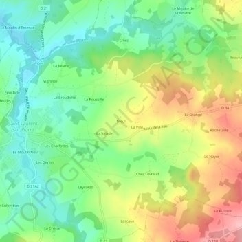
Name: Nieul topographic map, elevation, terrain.
Average elevation: 290 m
Minimum elevation: 235 m
Maximum elevation: 370 m
Other topographic maps
Click on a map to view its topography, its elevation and its terrain.
Cubes
France > Nouvelle-Aquitaine > Haute-Vienne > Saint-Laurent-sur-Gorre
Cubes, Saint-Laurent-sur-Gorre, Rochechouart, Haute-Vienne, Nouvelle-Aquitaine, France métropolitaine, 87310, France
Average elevation: 307 m
Limouret
France > Nouvelle-Aquitaine > Haute-Vienne > Saint-Laurent-sur-Gorre
Limouret, Saint-Laurent-sur-Gorre, Rochechouart, Haute-Vienne, Nouvelle-Aquitaine, France métropolitaine, 87310, France
Average elevation: 340 m
La Ville
France > Nouvelle-Aquitaine > Haute-Vienne > Saint-Laurent-sur-Gorre
La Ville, Saint-Laurent-sur-Gorre, Rochechouart, Haute-Vienne, Nouvelle-Aquitaine, France métropolitaine, 87310, France
Average elevation: 295 m