
Make a donation
Mahilyow Region topographic map
Click on the map to display elevation.
Make a donation
About this map
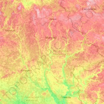
Name: Mahilyow Region topographic map, elevation, terrain.
Location: Mahilyow Region, Belarus (52.67457 28.08173 54.47427 32.76278)
Average elevation: 167 m
Minimum elevation: 111 m
Maximum elevation: 273 m
Make a donation
Other topographic maps
Click on a map to view its topography, its elevation and its terrain.
Highest point of the Kapyl hill chain
Belarus > Minsk Region > Kapyl District > Пацейкаўскі сельскі Савет
Average elevation: 227 m
Гара Красная
Belarus > Minsk Region > Uzda District > Слабадскі сельскі Савет
Average elevation: 174 m
Слімяны
Belarus > Hrodna Region > Ashmyany District > Крайванцаўскі сельскі Савет
Average elevation: 232 m
Dnieper
Belarus > Homyel Region > Brahin District > Новаялчанскі сельскі Савет
The source of the Dnieper is the sedge bogs (Akseninsky Mokh) of the Valdai Hills in central Russia, at an elevation of 220 m (720 ft). For 115 km (71 mi) of its length, it serves as the border between Belarus and Ukraine. Its estuary, or liman, used to be defended by the strong fortress of Ochakiv.
Average elevation: 106 m
Make a donation
Dnieper
Belarus > Homyel Region > Brahin District > Новаялчанскі сельскі Савет
The source of the Dnieper is the sedge bogs (Akseninsky Mokh) of the Valdai Hills in central Russia, at an elevation of 220 m (720 ft). For 115 km (71 mi) of its length, it serves as the border between Belarus and Ukraine. Its estuary, or liman, used to be defended by the strong fortress of Ochakiv.
Average elevation: 106 m
Make a donation
озеро Ёди
Belarus > Hrodna Region > Astravyets District > Михалишковский сельский Совет
Average elevation: 140 m