
Thank you for supporting this site ❤️
Make a donation
Make a donation
Amelscheid topographic map
Click on the map to display elevation.
Thank you for supporting this site ❤️
Make a donation
Make a donation
About this map
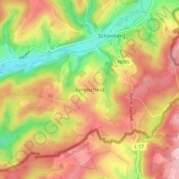
Name: Amelscheid topographic map, elevation, terrain.
Location: Amelscheid, Sankt Vith, Verviers, Luik, Wallonië, 4780, België (50.25675 6.23650 50.29675 6.27650)
Average elevation: 494 m
Minimum elevation: 406 m
Maximum elevation: 566 m
Thank you for supporting this site ❤️
Make a donation
Make a donation
Other topographic maps
Click on a map to view its topography, its elevation and its terrain.