
Georgetown Lake topographic map
Interactive map
Click on the map to display elevation.
About this map
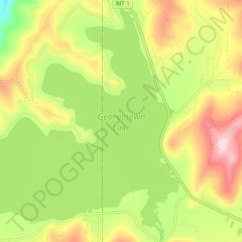
Name: Georgetown Lake topographic map, elevation, terrain.
Location: Georgetown Lake, Deer Lodge County, Montana, United States (46.16650 -113.32903 46.21504 -113.26230)
Average elevation: 1,968 m
Minimum elevation: 1,814 m
Maximum elevation: 2,137 m
Other topographic maps
Click on a map to view its topography, its elevation and its terrain.
Anaconda
United States > Montana > Deer Lodge County
Anaconda, Deer Lodge County, Montana, 59711, United States
Average elevation: 1,753 m