
Make a donation
Makkah Region topographic map
Click on the map to display elevation.
Make a donation
Makkah Region
Most of the central and eastern portions of the province are desert, with the Hejaz mountains, which vary in elevation from 600 meters to 2000 meters, separating the relatively flat Nafud desert and coastal plains. Agriculture takes place in the region's many wadis and oases, with the most commonly-grown crops being dates and barley, alongside other vegetables and fruits. The city of Ta'if is famous for its cultivation of the Rosa × damascena flower, simplified as Damask rose and locally known as Ta'if rose.
Make a donation
About this map
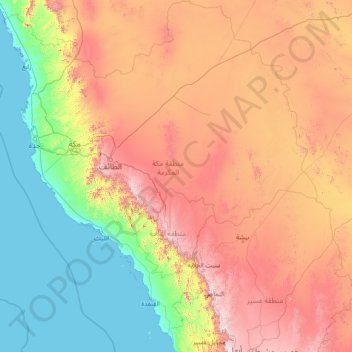
Name: Makkah Region topographic map, elevation, terrain.
Location: Makkah Region, Saudi Arabia (18.28122 38.65977 23.69520 43.83016)
Average elevation: 785 m
Minimum elevation: -4 m
Maximum elevation: 2,910 m
Make a donation
Other topographic maps
Click on a map to view its topography, its elevation and its terrain.
Abha
Abha is located in the southern region of Asir at an elevation of about 2,270 metres (7,450 feet) above sea level. Abha lies on the western edge of Mount Al-Hijaz, near Jabal Sawda, the highest peak in Saudi Arabia. Treating the Asir Mountains as part of the Sarawat, the landscape is otherwise dominated by the…
Average elevation: 1,994 m