
Volos topographic map
Interactive map
Click on the map to display elevation.
About this map
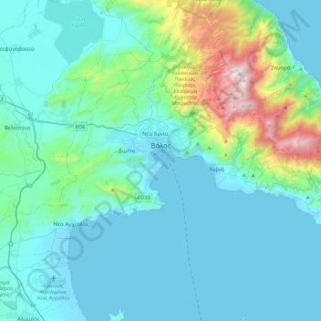
Name: Volos topographic map, elevation, terrain.
Average elevation: 228 m
Minimum elevation: -3 m
Maximum elevation: 1,604 m
Other topographic maps
Click on a map to view its topography, its elevation and its terrain.
Agii Apostoli
Griechenland > Thessalien - Mittelgriechenland > Regionalbezirk Magnisia > Almyros
Agii Apostoli, Δημοτική Ενότητα Πτελεού, Almyros, Regionalbezirk Magnisia, Region Thessalien, Thessalien - Mittelgriechenland, 370 07, Griechenland
Average elevation: 32 m