
Make a donation
Issyk-Kul topographic map
Click on the map to display elevation.
Make a donation
Issyk-Kul
Issyk-Kul (also Ysyk-Köl, Kyrgyz: Ысык-Көл, romanized: Ysyk-Köl, lit. 'warm lake', [ɯsɯk kœl]) is an endorheic (i.e., without outflow) saline lake in the western Tianshan Mountains in eastern Kyrgyzstan, just south of a dividing range separating Kyrgyzstan from Kazakhstan. It is the seventh-deepest lake in the world, the tenth-largest lake in the world by volume (though not in surface area) and the third-largest saline lake. Issyk-Kul means "warm lake" in the Kyrgyz language; although it is located at a lofty elevation of 1,607 metres (5,272 ft) and subject to severe cold during winter, it rarely freezes, due to the salinity.
Make a donation
About this map
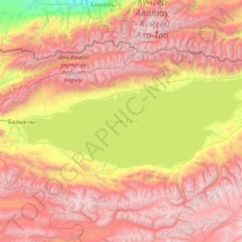
Name: Issyk-Kul topographic map, elevation, terrain.
Location: Issyk-Kul, Issyk-Kul Region, Kyrgyzstan (42.15422 76.18366 42.76987 78.32748)
Average elevation: 2,589 m
Minimum elevation: 762 m
Maximum elevation: 4,922 m
Make a donation
Other topographic maps
Click on a map to view its topography, its elevation and its terrain.