
Étang de Brindos topographic map
Interactive map
Click on the map to display elevation.
About this map
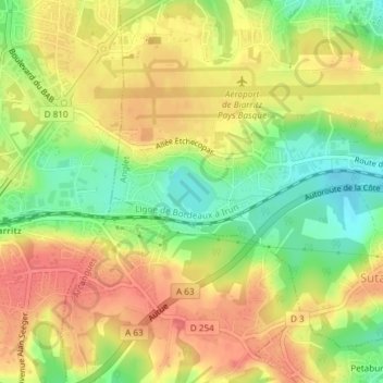
Name: Étang de Brindos topographic map, elevation, terrain.
Average elevation: 60 m
Minimum elevation: 24 m
Maximum elevation: 87 m
Other topographic maps
Click on a map to view its topography, its elevation and its terrain.
Blancpignon
France > Nouvelle-Aquitaine > Pyrénées-Atlantiques > Anglet > Blancpignon
Blancpignon, Anglet, Bayonne, Pyrénées-Atlantiques, Nouvelle-Aquitaine, France métropolitaine, 64600, France
Average elevation: 14 m