
Thank you for supporting this site ❤️
Make a donation
Make a donation
Ahlstadt topographic map
Click on the map to display elevation.
Thank you for supporting this site ❤️
Make a donation
Make a donation
About this map
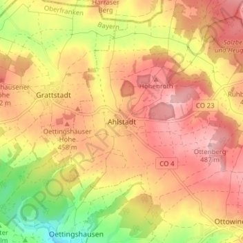
Name: Ahlstadt topographic map, elevation, terrain.
Location: Ahlstadt, Meeder, Landkreis Coburg, Bayern, Deutschland (50.35128 10.83579 50.39128 10.87579)
Average elevation: 435 m
Minimum elevation: 344 m
Maximum elevation: 493 m
Thank you for supporting this site ❤️
Make a donation
Make a donation
Other topographic maps
Click on a map to view its topography, its elevation and its terrain.
Thank you for supporting this site ❤️
Make a donation
Make a donation
Thank you for supporting this site ❤️
Make a donation
Make a donation
Meeder
Deutschland > Bayern > Landkreis Coburg
Auf der Sennigshöhe (geographische Koordinaten: 50° 21′ 20″ N, 10° 54′ 56″ O50.35555555555610.915555555556) betreibt die Deutsche Telekom AG seit 1965 eine Sendeanlage für UKW-Hörfunk, Mobilfunk und Richtfunk.
Average elevation: 398 m
96465
Deutschland > Bayern > Landkreis Coburg > Neustadt bei Coburg > Haarbrücken
Average elevation: 372 m
Thank you for supporting this site ❤️
Make a donation
Make a donation
Thank you for supporting this site ❤️
Make a donation
Make a donation
Thank you for supporting this site ❤️
Make a donation
Make a donation