
Darmstadt topographic map
Click on the map to display elevation.
About this map
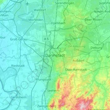
Name: Darmstadt topographic map, elevation, terrain.
Location: Darmstadt, Hesse, 64283, Germany (49.71278 8.49118 50.03278 8.81118)
Average elevation: 151 m
Minimum elevation: 82 m
Maximum elevation: 604 m
Other topographic maps
Click on a map to view its topography, its elevation and its terrain.
Wiesbaden
The highest point of the Wiesbaden municipality is located northwest of the city center near the summit of the Hohe Wurzel, with an elevation of 608 metres (1,995 ft) above sea level. The lowest point is the harbour entrance of Schierstein at 83 metres (272 ft) above sea level. The central square (the…
Average elevation: 221 m
Flieden
Germany > Hesse > Landkreis Fulda
Flieden is located in a valley north west of the Landrücken between the Vogelsberg and the Rhön. It is an area of low hills with the highest elevations being Knöschen near Buchenrod (509 m) and the Storker Küppel near Oberstork (470 m). At the very center of Flieden the creeks Magdloser Wasser und Kautzer…
Average elevation: 376 m
Wiesbaden
The highest point of the Wiesbaden municipality is located northwest of the city center near the summit of the Hohe Wurzel, with an elevation of 608 metres (1,995 ft) above sea level. The lowest point is the harbour entrance of Schierstein at 83 metres (272 ft) above sea level. The central square (the…
Average elevation: 221 m
Hadamar
Germany > Hesse > Landkreis Limburg-Weilburg
Hadamar lies 7 km north of Limburg between Cologne and Frankfurt am Main on the southern edge of the Westerwald at elevations from 120 to 390 m above sea level.
Average elevation: 215 m
Wetzlar
Germany > Hesse > Lahn-Dill-Kreis
Wetzlar has a year-round temperate seasonal climate of the middle latitudes. Between the different elevations there are different small climatic conditions. The daily mean temperature in summer is about 17 to 18 °C (63 to 64 °F) and in winter about 1 to 2 °C (34 to 36 °F). The average rainfall is 600 to…
Average elevation: 228 m
Taunus
Hintertaunus is the name given to the area north of the Hoher Taunus up to the Lahn valley. The landscape here is lower and less mountainous than in the southern Taunus. Between the valleys, some of which are quite deep, there are pronounced plateaus (leveled areas) with heavy agricultural use. Since mostly…
Average elevation: 280 m
Bad Hersfeld
Germany > Hesse > Landkreis Hersfeld-Rotenburg
The Flugplatz Johannesberg has the status of Special Airfield. The runway, some 671 m long and 18 m wide, is paved with asphalt and oriented in a north–south direction. The airfield lies on the Johannesberg in the like-named outlying centre at an elevation of 284 m above sea level.
Average elevation: 305 m
Eschborn
Germany > Hesse > Main-Taunus-Kreis
Eschborn provides expansive views of the Taunus mountain ranges, especially the 'Altkönig' and behind it the 'Feldberg' up to elevations of around 880 m above sealevel. From Eschborn to the north there are numerous hiking and biking trails leading up to these green mountain zones. In winter, along and up…
Average elevation: 146 m
Igstadt
Igstadt is situated on the eastern slope of the Wäschbachtal valley at an elevation of 169 to 211 m above sea level. It is traversed by the Wiesbaden-Niedernhausen rail line. It is surrounded by agricultural land. Recreational areas include the Wickerbachtal Nature Reserve between Igstadt and Kloppenheim.
Average elevation: 198 m
Heusenstamm
Germany > Hesse > Landkreis Offenbach
Heusenstamm is one of 13 towns and communities in the Offenbach district. The town lies in the Frankfurt Rhine Main Region south of Frankfurt am Main and Offenbach am Main at an average elevation of 121 m above sea level. The town lies on the river Bieber. The lowest natural point is the Bieber's riverbed, and…
Average elevation: 129 m
Zwingenberg
Germany > Hesse > Kreis Bergstraße
Zwingenberg lies on the western edge of the Odenwald at the foot of the Melibokus, at 517.4 m above sea level the Bergstraße's highest mountain. The municipal area's elevation varies between roughly 90 m above sea level in the outlying centre of Rodau and just under 300 m on the slope of the Melibokus.…
Average elevation: 104 m