
Thank you for supporting this site ❤️
Make a donation
Make a donation
Cascade Range topographic map
Click on the map to display elevation.
Thank you for supporting this site ❤️
Make a donation
Make a donation
About this map
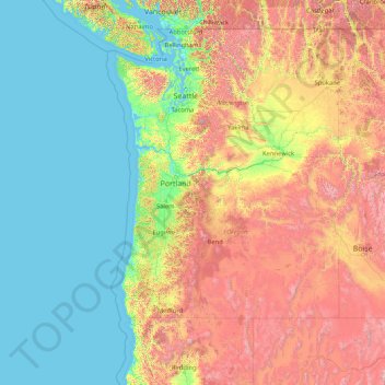
Name: Cascade Range topographic map, elevation, terrain.
Average elevation: 690 m
Minimum elevation: -3 m
Maximum elevation: 3,899 m
Thank you for supporting this site ❤️
Make a donation
Make a donation
Other topographic maps
Click on a map to view its topography, its elevation and its terrain.
Washington Park
United States of America > Oregon > Portland
Washington Park covers more than 458 acres (185 hectares) on mostly steep, wooded hillsides which range in elevation from 200 feet (61 m) at 24th & West Burnside Street to 870 feet (265 m) at SW Fairview Blvd. It comprises 241.45 acres (97.71 hectares) of city park land that has been officially designated as…
Average elevation: 169 m