
Thank you for supporting this site ❤️
Make a donation
Make a donation
Park Vliegbasis Soesterberg topographic map
Click on the map to display elevation.
Thank you for supporting this site ❤️
Make a donation
Make a donation
About this map
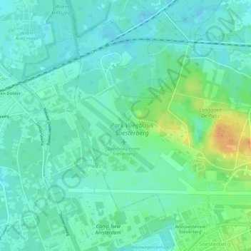
Name: Park Vliegbasis Soesterberg topographic map, elevation, terrain.
Location: Park Vliegbasis Soesterberg, Soest, Utrecht, Nederland (52.12517 5.25103 52.14585 5.30162)
Average elevation: 13 m
Minimum elevation: 3 m
Maximum elevation: 36 m
Thank you for supporting this site ❤️
Make a donation
Make a donation
Other topographic maps
Click on a map to view its topography, its elevation and its terrain.