
Thank you for supporting this site ❤️
Make a donation
Make a donation
Chelyabinsk topographic map
Click on the map to display elevation.
Thank you for supporting this site ❤️
Make a donation
Make a donation
Chelyabinsk
Shortly after dawn on 15 February 2013, a superbolide meteor descended at over 55,000 kilometers per hour (34,000 mph) over the Ural Mountains, exploding at an altitude of 25–30 kilometers (16–19 mi).
Thank you for supporting this site ❤️
Make a donation
Make a donation
About this map
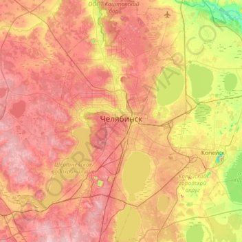
Name: Chelyabinsk topographic map, elevation, terrain.
Location: Chelyabinsk, Chelyabinsk Oblast, Ural Federal District, Russia (54.99100 61.14360 55.32098 61.59206)
Average elevation: 230 m
Minimum elevation: 147 m
Maximum elevation: 297 m
Thank you for supporting this site ❤️
Make a donation
Make a donation
Other topographic maps
Click on a map to view its topography, its elevation and its terrain.