Geolocate

Roz An Bidou topographic map

Interactive map

Click on the map to display elevation.

About this map

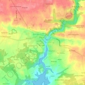
Name: Roz An Bidou topographic map, elevation, terrain.

Location: Roz An Bidou, Nizon, Pont-Aven, Quimper, Finistère, Bretagne, France métropolitaine, 29930, France (47.83459 -3.77010 47.87459 -3.73010)

Average elevation: 48 m

Minimum elevation: 0 m

Maximum elevation: 86 m

Other topographic maps

Click on a map to view its topography, its elevation and its terrain.

Kergazuel

France > Bretagne > Finistère > Nizon

Kergazuel, Nizon, Pont-Aven, Quimper, Finistère, Bretagne, France métropolitaine, 29930, France

Average elevation: 74 m

Croissant Kergoz

France > Bretagne > Finistère > Nizon

Croissant Kergoz, Nizon, Pont-Aven, Quimper, Finistère, Bretagne, France métropolitaine, 29930, France

Average elevation: 52 m

Kergam

France > Bretagne > Finistère > Nizon

Kergam, Nizon, Pont-Aven, Quimper, Finistère, Bretagne, France métropolitaine, 29930, France

Average elevation: 50 m

Rue de la Villemarqué

France > Bretagne > Finistère > Nizon > Kergam

Rue de la Villemarqué, Rue Émile Bernard, Keranna, Kergam, Nizon, Pont-Aven, Quimper, Finistère, Bretagne, France métropolitaine, 29930, France

Average elevation: 49 m

Kergoz

France > Bretagne > Finistère > Nizon

Kergoz, Nizon, Pont-Aven, Quimper, Finistère, Bretagne, France métropolitaine, 29930, France

Average elevation: 54 m