
Thank you for supporting this site ❤️
Make a donation
Make a donation
Pegnitz topographic map
Click on the map to display elevation.
Thank you for supporting this site ❤️
Make a donation
Make a donation
About this map
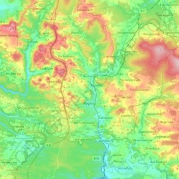
Name: Pegnitz topographic map, elevation, terrain.
Location: Pegnitz, Landkreis Bayreuth, Bavaria, 91257, Germany (49.69628 11.42391 49.83802 11.63376)
Average elevation: 485 m
Minimum elevation: 392 m
Maximum elevation: 637 m
Thank you for supporting this site ❤️
Make a donation
Make a donation
Other topographic maps
Click on a map to view its topography, its elevation and its terrain.
Bad Berneck
Germany > Bavaria > Landkreis Bayreuth > Bad Berneck im Fichtelgebirge
Average elevation: 474 m
Thank you for supporting this site ❤️
Make a donation
Make a donation
Thank you for supporting this site ❤️
Make a donation
Make a donation