
Armañanzas topographic map
Interactive map
Click on the map to display elevation.
About this map
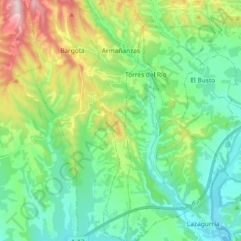
Name: Armañanzas topographic map, elevation, terrain.
Location: Armañanzas, Montejurra, Navarre, Espagne (42.48675 -2.30687 42.58008 -2.27239)
Average elevation: 492 m
Minimum elevation: 377 m
Maximum elevation: 787 m
Other topographic maps
Click on a map to view its topography, its elevation and its terrain.
Torres del Río
Espagne > Navarre > Montejurra
Torres del Río, Montejurra, Navarre, Espagne
Average elevation: 469 m
Lerate
Espagne > Navarre > Montejurra > Guesálaz
Lerate, Guesálaz, Montejurra, Navarre, 31291, Espagne
Average elevation: 527 m