Geolocate

九合乡 topographic map

Interactive map

Click on the map to display elevation.

About this map

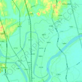
Name: 九合乡 topographic map, elevation, terrain.

Location: 九合乡, 永修县, 九江市, 江西省, 中国 (29.04765 115.81107 29.13788 115.92575)

Average elevation: 20 m

Minimum elevation: 9 m

Maximum elevation: 55 m

Other topographic maps

Click on a map to view its topography, its elevation and its terrain.

三角乡

中国 > 江西省 > 永修县

三角乡, 永修县, 九江市, 江西省, 中国

Average elevation: 18 m

立新乡

中国 > 江西省 > 永修县

立新乡, 永修县, 九江市, 江西省, 中国

Average elevation: 25 m

永修县

中国 > 江西省 > 永修县 > 涂埠镇

永修县, 涂埠镇, 永修县, 九江市, 江西省, 中国

Average elevation: 28 m

淳湖村

中国 > 江西省 > 永修县 > 九合乡

淳湖村, 九合乡, 永修县, 九江市, 江西省, 中国

Average elevation: 18 m

杨柳津河

中国 > 江西省 > 永修县 > 九合乡 > 河头村

杨柳津河, 河头村, 九合乡, 永修县, 九江市, 江西省, 中国

Average elevation: 22 m

鄱阳湖

中国 > 江西省 > 永修县

鄱阳湖, 永修县, 九江市, 江西省, 中国

Average elevation: 62 m