
Thank you for supporting this site ❤️
Make a donation
Make a donation
Llavorsí topographic map
Click on the map to display elevation.
Thank you for supporting this site ❤️
Make a donation
Make a donation
About this map
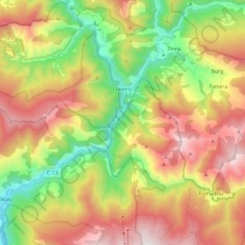
Name: Llavorsí topographic map, elevation, terrain.
Location: Llavorsí, Pallars Sobirà, Lerida, Catalonië, 25595, Spanje (42.42124 1.11150 42.53801 1.25607)
Average elevation: 1,419 m
Minimum elevation: 694 m
Maximum elevation: 2,265 m
Thank you for supporting this site ❤️
Make a donation
Make a donation
Other topographic maps
Click on a map to view its topography, its elevation and its terrain.