
Löwenberg topographic map
Interactive map
Click on the map to display elevation.
About this map
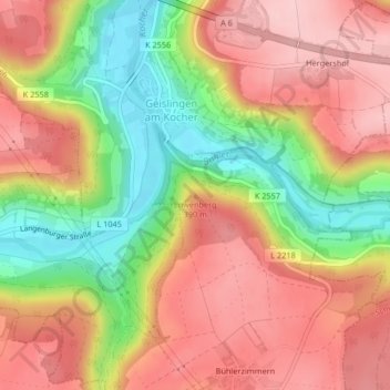
Name: Löwenberg topographic map, elevation, terrain.
Average elevation: 356 m
Minimum elevation: 245 m
Maximum elevation: 441 m
Other topographic maps
Click on a map to view its topography, its elevation and its terrain.
Schloss Tierberg
Deutschland > Baden-Württemberg > Braunsbach > Tierberg
Schloss Tierberg, Tierberg, Braunsbach, Verwaltungsverband Braunsbach-Untermünkheim, Landkreis Schwäbisch Hall, Baden-Württemberg, 74542, Deutschland
Average elevation: 393 m