
Thank you for supporting this site ❤️
Make a donation
Make a donation
Saïda topographic map
Click on the map to display elevation.
Thank you for supporting this site ❤️
Make a donation
Make a donation
About this map
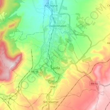
Name: Saïda topographic map, elevation, terrain.
Location: Saïda, Saïda District, Saïda, Algeria (34.78766 0.07043 34.90029 0.21446)
Average elevation: 906 m
Minimum elevation: 699 m
Maximum elevation: 1,200 m
Thank you for supporting this site ❤️
Make a donation
Make a donation