
Thank you for supporting this site ❤️
Make a donation
Make a donation
Dharapuram topographic map
Click on the map to display elevation.
Thank you for supporting this site ❤️
Make a donation
Make a donation
About this map
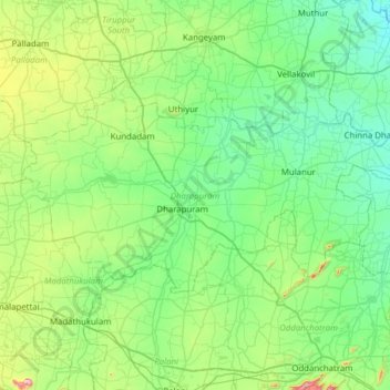
Name: Dharapuram topographic map, elevation, terrain.
Location: Dharapuram, Tiruppur District, Tamil Nadu, India (10.60481 77.27105 10.91073 77.89276)
Average elevation: 290 m
Minimum elevation: 149 m
Maximum elevation: 894 m
Thank you for supporting this site ❤️
Make a donation
Make a donation
Other topographic maps
Click on a map to view its topography, its elevation and its terrain.
Dharapuram
India > Tamil Nadu > Dharapuram
Dharapuram is located at 10°44′N 77°31′E / 10.73°N 77.52°E / 10.73; 77.52. Dharapuram town is situated along of the bank of Amaravathi River which flows from the south to north. Uppar River and dam, Nallathankal River and dam, Palar join the river Amaravathi. It has an average elevation of 45…
Average elevation: 252 m