
Thank you for supporting this site ❤️
Make a donation
Make a donation
Campanario topographic map
Click on the map to display elevation.
Thank you for supporting this site ❤️
Make a donation
Make a donation
About this map
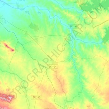
Name: Campanario topographic map, elevation, terrain.
Location: Campanario, Badajoz, Extremadura, 06460, Spain (38.78086 -5.79402 38.99071 -5.48203)
Average elevation: 354 m
Minimum elevation: 253 m
Maximum elevation: 593 m
Thank you for supporting this site ❤️
Make a donation
Make a donation
Other topographic maps
Click on a map to view its topography, its elevation and its terrain.
Madrigal de la Vera
Spain > Extremadura > La Vera > Madrigal de la Vera > Madrigal de la Vera
Average elevation: 400 m
Thank you for supporting this site ❤️
Make a donation
Make a donation