
Bocquencé topographic map
Interactive map
Click on the map to display elevation.
About this map
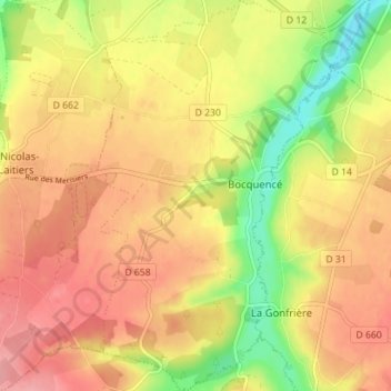
Name: Bocquencé topographic map, elevation, terrain.
Average elevation: 259 m
Minimum elevation: 203 m
Maximum elevation: 296 m
Other topographic maps
Click on a map to view its topography, its elevation and its terrain.
Glos-la-Ferrière
France > Normandie > Orne > La Ferté-en-Ouche
Glos-la-Ferrière, La Ferté-en-Ouche, Mortagne-au-Perche, Orne, Normandie, France métropolitaine, 61550, France
Average elevation: 239 m
La Ferté-Frênel
France > Normandie > Orne > La Ferté-en-Ouche
La Ferté-Frênel, La Ferté-en-Ouche, Mortagne-au-Perche, Orne, Normandie, France métropolitaine, 61550, France
Average elevation: 264 m
Anceins
France > Normandie > Orne > La Ferté-en-Ouche
Anceins, La Ferté-en-Ouche, Mortagne-au-Perche, Orne, Normandie, France métropolitaine, 61550, France
Average elevation: 239 m