
Hillsboro topographic map
Interactive map
Click on the map to display elevation.
About this map
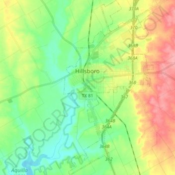
Name: Hillsboro topographic map, elevation, terrain.
Location: Hillsboro, Hill County, Texas, 76645, United States (31.94316 -97.14862 32.05685 -97.08000)
Average elevation: 196 m
Minimum elevation: 161 m
Maximum elevation: 251 m
Other topographic maps
Click on a map to view its topography, its elevation and its terrain.
Blum
United States > Texas > Hill County
Blum, Hill County, Texas, United States
Average elevation: 190 m
Brandon
United States > Texas > Hill County
Brandon, Hill County, Texas, 76628, United States
Average elevation: 188 m
Penelope
United States > Texas > Hill County > Penelope
Penelope, Hill County, Texas, 76676, United States
Average elevation: 170 m