
Make a donation
Izola / Isola topographic map
Click on the map to display elevation.
Make a donation
About this map
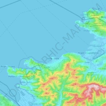
Name: Izola / Isola topographic map, elevation, terrain.
Average elevation: 49 m
Minimum elevation: -5 m
Maximum elevation: 401 m
Make a donation
Other topographic maps
Click on a map to view its topography, its elevation and its terrain.
Triglav
Triglav (pronounced [ˈtɾiːɡlau̯]; German: Terglau; Italian: Tricorno), with an elevation of 2,863.65 metres (9,395.2 ft), is the highest mountain in Slovenia and the highest peak of the Julian Alps. The mountain is the pre-eminent symbol of the Slovene nation, appearing on the coat of arms and flag of…
Average elevation: 2,161 m
Murska Sobota
Annual rainfall in Murska Sobota is among the lowest in Slovenia. Characterized by the instability of rainfall, severe droughts are frequent. It has a warm-summer humid continental climate (Dfb) that is uncommon in Slovenia except at higher elevations,
Average elevation: 191 m
Make a donation
Make a donation
Kras
It lies between the Vipava Valley, the low hills surrounding the valley, the westernmost part of the Brkini Hills, northern Istria, and the Gulf of Trieste. The western edge of the plateau also marks the traditional ethnic border between Italians and Slovenes. The region gave its name to karst topography. For…
Average elevation: 423 m
Make a donation
Make a donation
Mangart
Mangart or Mangrt is a mountain in the Julian Alps, located on the border between Italy and Slovenia. With an elevation of 2,679 metres (8,789 ft), it is the fourth-highest peak in Slovenia, after Triglav, Škrlatica and Mali Triglav. It was first climbed in 1794 by the naturalist Franz von Hohenwart. Mangart…
Average elevation: 1,800 m
Triglav
Triglav (pronounced [ˈtɾíːɡlaw]; German: Terglau; Italian: Tricorno), with an elevation of 2,863.65 metres (9,395 ft 2+1⁄8 in), is the highest mountain in Slovenia and the highest peak of the Julian Alps. The mountain is the pre-eminent symbol of the Slovene nation, appearing on the coat of arms and…
Average elevation: 2,161 m
Make a donation
Ljubljana
Ljubljana has an elevation of 295 meters (968 ft) The city centre, located along the Ljubljanica River, has an elevation of 298 meters (978 ft). Ljubljana Castle, which sits atop Castle Hill (Grajski grič) south of the city centre, has an elevation of 366 meters (1,201 ft). The highest point of the city,…
Average elevation: 412 m
Make a donation
Make a donation
Make a donation
Strmec na Predelu
Slovenia > Bovec > Log pod Mangartom
Strmec na Predelu (pronounced [ˈstəɾməts na pɾɛˈdeːlu]; Italian: Bretto di Sopra) is a settlement in the Municipality of Bovec in the Littoral region of Slovenia. It lies on the road to the Predel Pass. Another road, distinguished by being the road built at the highest elevation in Slovenia, splits off…
Average elevation: 1,141 m
Make a donation
Make a donation
Make a donation
Triglav
Triglav (pronounced [ˈtɾiːɡlau̯]; German: Terglau; Italian: Tricorno), with an elevation of 2,863.65 metres (9,395 ft 2+1⁄8 in), is the highest mountain in Slovenia and the highest peak of the Julian Alps. The mountain is the pre-eminent symbol of the Slovene nation, appearing on the coat of arms and…
Average elevation: 2,161 m
Make a donation
Make a donation
Gornji Slaveči
The name Gornji Slaveči (literally, 'upper Slaveči') contrasts with the name Dolnji Slaveči (literally, 'lower Slaveči'), a village in the neighboring Municipality of Grad. Dolnji Slaveči lies about 20 meters (66 ft) lower in elevation than Gornji Slaveči.
Average elevation: 287 m
Make a donation
Make a donation
Make a donation
Make a donation
Make a donation
Make a donation
Golo
Golo is a clustered village with two settlement centers: the hamlets of Gorenje Golo (German: Obergolu) and Dolenje Golo (German: Untergolu). It lies along the road from Ig to Visoko northeast of Mount Mokrec (elevation: 1,059 meters or 3,474 feet). Golec Hill (elevation: 766 meters or 2,513 feet) rises to the…
Average elevation: 579 m
Make a donation
Make a donation
Make a donation
Make a donation
Make a donation