
Thank you for supporting this site ❤️
Make a donation
Make a donation
Seggiano topographic map
Click on the map to display elevation.
Thank you for supporting this site ❤️
Make a donation
Make a donation
Seggiano
With the exception of units of low hill near the beds of rivers, the region extends mainly in hilly and mountainous odds, but good exposure allows the cultivation of a cultivar of olive, Olivastra Seggianese, called up to elevations of low mountains, managing to produce an oil of excellent quality.
Thank you for supporting this site ❤️
Make a donation
Make a donation
About this map
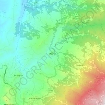
Name: Seggiano topographic map, elevation, terrain.
Average elevation: 550 m
Minimum elevation: 160 m
Maximum elevation: 1,495 m
Thank you for supporting this site ❤️
Make a donation
Make a donation
Other topographic maps
Click on a map to view its topography, its elevation and its terrain.
Thank you for supporting this site ❤️
Make a donation
Make a donation
Thank you for supporting this site ❤️
Make a donation
Make a donation
Thank you for supporting this site ❤️
Make a donation
Make a donation
Thank you for supporting this site ❤️
Make a donation
Make a donation
Thank you for supporting this site ❤️
Make a donation
Make a donation
Thank you for supporting this site ❤️
Make a donation
Make a donation