
Debila topographic map
Interactive map
Click on the map to display elevation.
About this map
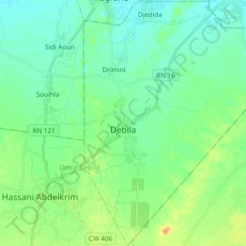
Name: Debila topographic map, elevation, terrain.
Location: Debila, Daïra Debila, El Oued, Algérie (33.45618 6.91716 33.56133 7.02762)
Average elevation: 59 m
Minimum elevation: 48 m
Maximum elevation: 85 m
Other topographic maps
Click on a map to view its topography, its elevation and its terrain.
Hassani Abdelkrim
Algérie > El Oued > Daïra Debila > Hassani Abdelkrim
Hassani Abdelkrim, Daïra Debila, El Oued, Algérie
Average elevation: 67 m