
Thank you for supporting this site ❤️
Make a donation
Make a donation
Grimminge topographic map
Click on the map to display elevation.
Thank you for supporting this site ❤️
Make a donation
Make a donation
Grimminge
Grimminge ligt op een hoogte van 13-44 meter aan de Dender. Aan de Dender ligt ook het natuurgebied Gemene Meers.
Thank you for supporting this site ❤️
Make a donation
Make a donation
About this map
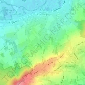
Name: Grimminge topographic map, elevation, terrain.
Average elevation: 42 m
Minimum elevation: 8 m
Maximum elevation: 108 m
Thank you for supporting this site ❤️
Make a donation
Make a donation
Other topographic maps
Click on a map to view its topography, its elevation and its terrain.
Denderarm Sluis Geeraardsbergen
België > Oost-Vlaanderen > Aalst > Geraardsbergen
Average elevation: 38 m
Thank you for supporting this site ❤️
Make a donation
Make a donation
Provinciaal Domein "De Gavers"
België > Oost-Vlaanderen > Aalst > Geraardsbergen
Average elevation: 23 m