
Thank you for supporting this site ❤️
Make a donation
Make a donation
Uffington topographic map
Click on the map to display elevation.
Thank you for supporting this site ❤️
Make a donation
Make a donation
About this map
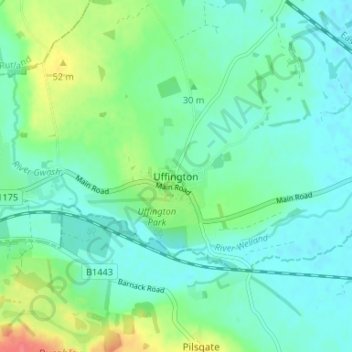
Name: Uffington topographic map, elevation, terrain.
Average elevation: 30 m
Minimum elevation: 14 m
Maximum elevation: 74 m
Thank you for supporting this site ❤️
Make a donation
Make a donation
Other topographic maps
Click on a map to view its topography, its elevation and its terrain.
Uffington Park
United Kingdom > England > Lincolnshire > South Kesteven > Uffington
Average elevation: 30 m