
Thank you for supporting this site ❤️
Make a donation
Make a donation
Williams Village topographic map
Click on the map to display elevation.
Thank you for supporting this site ❤️
Make a donation
Make a donation
About this map
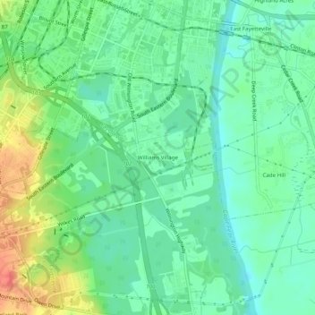
Name: Williams Village topographic map, elevation, terrain.
Average elevation: 30 m
Minimum elevation: 11 m
Maximum elevation: 67 m
Thank you for supporting this site ❤️
Make a donation
Make a donation
Other topographic maps
Click on a map to view its topography, its elevation and its terrain.
Blounts Creek
United States > North Carolina > Cumberland County > Fayetteville
Average elevation: 29 m