
Thank you for supporting this site ❤️
Make a donation
Make a donation
Eschlipp topographic map
Click on the map to display elevation.
Thank you for supporting this site ❤️
Make a donation
Make a donation
Eschlipp
Das im Süden der Heiligenstädter Flächenalb gelegene Dorf[2] befindet sich etwa vier Kilometer nordwestlich des Ortszentrums von Ebermannstadt auf einer Höhe von 474 m ü. NHN.[3]
Thank you for supporting this site ❤️
Make a donation
Make a donation
About this map
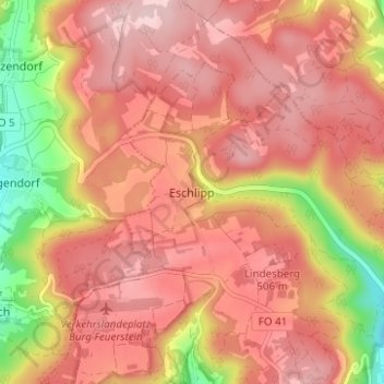
Name: Eschlipp topographic map, elevation, terrain.
Average elevation: 464 m
Minimum elevation: 320 m
Maximum elevation: 537 m
Thank you for supporting this site ❤️
Make a donation
Make a donation
Other topographic maps
Click on a map to view its topography, its elevation and its terrain.
Breitenbach
Deutschland > Bayern > Landkreis Forchheim > Ebermannstadt > Breitenbach
Average elevation: 368 m