Istria County topographic map
Click on the map to display elevation.
Istria County
The terrain consists of a limestone plateau much of which lacks water owing to its karst topography. The northeastern section is an extension of the Dinaric Alps. The highest point is Vojak on Učka mountain 1,401 m (4,596.46 ft) above sea level and there is another range of mountains, the Ćićarija.
About this map
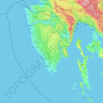
Name: Istria County topographic map, elevation, terrain.
Location: Istria County, Croatia (44.46893 13.21048 45.58838 14.25862)
Average elevation: 129 m
Minimum elevation: -5 m
Maximum elevation: 1,747 m
Other topographic maps
Click on a map to view its topography, its elevation and its terrain.

































Bijela
Croatia > Zadar County > Grad Obrovac > Gornji Karin
Bijela is one of the smallest rivers in northern Dalmatia, flowing from east to west, and enters Karin Sea at Gornji Karin, a village belonging to the Town of Obrovac in the Zadar County. The spring of Bijela is located at an altitude of approximately 300 meters, below the Pržun mountain peak (351 meters…
Average elevation: 87 m













Osijek
Croatia > Osijek-Baranja County > Osijek
Osijek (Croatian pronunciation: (listen)) is the fourth largest city in Croatia with a population of 108,048 in 2011. It is the largest city and the economic and cultural centre of the eastern Croatian region of Slavonia, as well as the administrative centre of Osijek-Baranja County. Osijek is located on the…
Average elevation: 87 m