
Härtensdorf topographic map
Interactive map
Click on the map to display elevation.
About this map
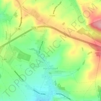
Name: Härtensdorf topographic map, elevation, terrain.
Location: Härtensdorf, Wildenfels, Zwickau, Sachsen, Deutschland (50.66827 12.58648 50.69474 12.63363)
Average elevation: 388 m
Minimum elevation: 327 m
Maximum elevation: 466 m
Other topographic maps
Click on a map to view its topography, its elevation and its terrain.
Wiesenburg
Deutschland > Sachsen > Zwickau > Wildenfels > Wiesenburg
Wiesenburg, Wildenfels, Zwickau, Sachsen, Deutschland
Average elevation: 362 m