
Sepi topographic map
Interactive map
Click on the map to display elevation.
About this map
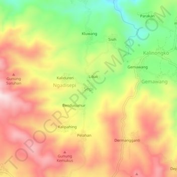
Name: Sepi topographic map, elevation, terrain.
Location: Sepi, Temanggung, Central Java, Java, Indonesia (-7.21989 110.11512 -7.17989 110.15512)
Average elevation: 694 m
Minimum elevation: 454 m
Maximum elevation: 898 m
Other topographic maps
Click on a map to view its topography, its elevation and its terrain.
Gunung Guntur
Indonesia > Central Java > Temanggung > Nglondong
Gunung Guntur, Nglondong, Temanggung, Central Java, Java, 56254, Indonesia
Average elevation: 724 m
Carikan
Indonesia > Central Java > Temanggung > Jumo
Carikan, Jumo, Temanggung, Central Java, Java, Indonesia
Average elevation: 750 m