
Thank you for supporting this site ❤️
Make a donation
Make a donation
Diepenbeek topographic map
Click on the map to display elevation.
Thank you for supporting this site ❤️
Make a donation
Make a donation
About this map
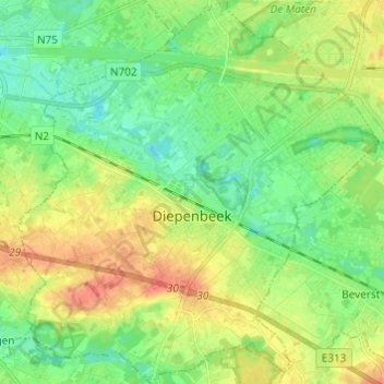
Name: Diepenbeek topographic map, elevation, terrain.
Location: Diepenbeek, Hasselt, Limbourg, 3590, Belgique (50.87419 5.36513 50.95070 5.47909)
Average elevation: 44 m
Minimum elevation: 27 m
Maximum elevation: 68 m
Thank you for supporting this site ❤️
Make a donation
Make a donation
Other topographic maps
Click on a map to view its topography, its elevation and its terrain.