
Thank you for supporting this site ❤️
Make a donation
Make a donation
Klein-Ternaaien topographic map
Click on the map to display elevation.
Thank you for supporting this site ❤️
Make a donation
Make a donation
About this map
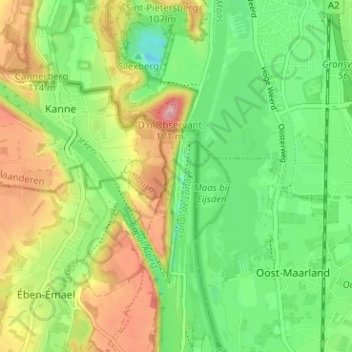
Name: Klein-Ternaaien topographic map, elevation, terrain.
Location: Klein-Ternaaien, Wezet, Luik, Wallonië, 4600, België (50.78653 5.67002 50.82653 5.71002)
Average elevation: 68 m
Minimum elevation: 10 m
Maximum elevation: 153 m
Thank you for supporting this site ❤️
Make a donation
Make a donation
Other topographic maps
Click on a map to view its topography, its elevation and its terrain.
Ternaaien
Ter hoogte van Klein-Ternaaien bevinden zich vier sluizen die een hoogteverschil van 15 meter overbruggen zodat ook grotere schepen van de Maas naar het Albertkanaal en omgekeerd kunnen varen. Het Kanaal van Ternaaien vormt de verbinding tussen beide waterwegen. Voor de bouw van het sluizencomplex was het niet…
Average elevation: 69 m