
Thank you for supporting this site ❤️
Make a donation
Make a donation
Bochum-Süd topographic map
Click on the map to display elevation.
Thank you for supporting this site ❤️
Make a donation
Make a donation
About this map
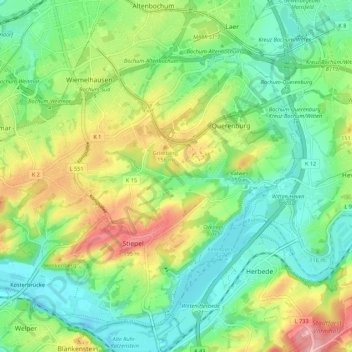
Name: Bochum-Süd topographic map, elevation, terrain.
Location: Bochum-Süd, Bochum, North Rhine-Westphalia, Germany (51.41052 7.18479 51.46996 7.29346)
Average elevation: 115 m
Minimum elevation: 65 m
Maximum elevation: 206 m
Thank you for supporting this site ❤️
Make a donation
Make a donation
Other topographic maps
Click on a map to view its topography, its elevation and its terrain.
Bochum
Germany > North Rhine-Westphalia > Bochum
The city lies on the low rolling hills of Bochum land ridge (Bochumer Landrücken), part of the Ruhrhöhen (highest elevations) between the Ruhr and Emscher rivers at the border of the southern and northern Ruhr coal region. The highest point of the city is at Kemnader Straße (Kemnader Street) in Stiepel at…
Average elevation: 107 m