
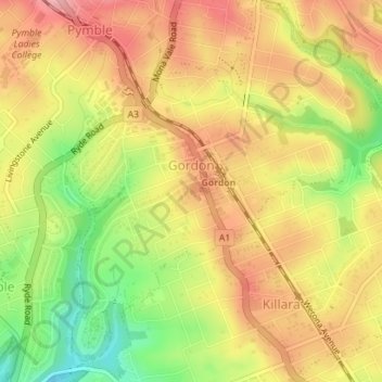
Gordon topographic map
Interactive map
Click on the map to display elevation.
About this map
Name: Gordon topographic map, elevation, terrain.
Location: Gordon, 悉尼, Ku-ring-gai Council, 新南威尔士州, 2072, 澳大利亚 (-33.77189 151.14030 -33.74282 151.17116)
Average elevation: 101 m
Minimum elevation: 23 m
Maximum elevation: 157 m
Other topographic maps
Click on a map to view its topography, its elevation and its terrain.
Castle Hill
Castle Hill, 悉尼, The Hills Shire Council, 新南威尔士州, 2154, 澳大利亚
Average elevation: 124 m
Chippendale
Chippendale, 悉尼, Council of the City of Sydney, 新南威尔士州, 2008, 澳大利亚
Average elevation: 29 m
Lake Parramatta
Lake Parramatta, North Parramatta, 悉尼, City of Parramatta Council, 新南威尔士州, 2151, 澳大利亚
Average elevation: 50 m
Denistone East
Denistone East, 悉尼, Council of the City of Ryde, 新南威尔士州, 2112, 澳大利亚
Average elevation: 66 m
Lovett Bay
Lovett Bay, 悉尼, Northern Beaches Council, Northern Beaches, 新南威尔士州, 2105, 澳大利亚
Average elevation: 78 m
Potts Hill
Potts Hill, 悉尼, Canterbury-Bankstown Council, 新南威尔士州, 2143, 澳大利亚
Average elevation: 44 m