Geolocate

Val Grande National Park topographic map

Interactive map

Click on the map to display elevation.

About this map

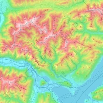
Name: Val Grande National Park topographic map, elevation, terrain.

Location: Val Grande National Park, Verbano-Cusio-Ossola, Piedmont, 28815, Italy (45.93639 8.26487 46.10718 8.62496)

Average elevation: 926 m

Minimum elevation: 188 m

Maximum elevation: 2,271 m

Other topographic maps

Click on a map to view its topography, its elevation and its terrain.

Prati

Italy > Piedmont > Verbano-Cusio-Ossola > Macugnaga

Average elevation: 1,809 m

Quarazza

Italy > Piedmont > Verbano-Cusio-Ossola > Macugnaga

Average elevation: 1,665 m

Cireggio

Italy > Piedmont > Verbano-Cusio-Ossola > Omegna

Average elevation: 514 m

Mottarone

Italy > Piedmont > Verbano-Cusio-Ossola > Stresa

Mottarone is a mountain in the Western Alps of Piedmont, north-western Italy, with an elevation of 1,492 metres (4,895 ft). It is located between the provinces of Verbano-Cusio-Ossola and Novara.

Average elevation: 1,177 m

Pianezza

Italy > Piedmont > Verbano-Cusio-Ossola > Bolco

Average elevation: 615 m

Oggiogno

Italy > Piedmont > Verbano-Cusio-Ossola

Average elevation: 573 m

Borca

Italy > Piedmont > Verbano-Cusio-Ossola > Omegna

Average elevation: 510 m