Thank you for supporting this site ❤️
Make a donation
Make a donation
West End topographic map
Click on the map to display elevation.
Thank you for supporting this site ❤️
Make a donation
Make a donation
About this map
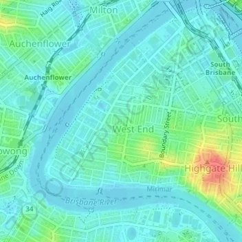
Name: West End topographic map, elevation, terrain.
Location: West End, City of Brisbane, Queensland, 4101, Australia (-27.49145 152.99531 -27.47341 153.01549)
Average elevation: 15 m
Minimum elevation: 3 m
Maximum elevation: 61 m
Thank you for supporting this site ❤️
Make a donation
Make a donation
Other topographic maps
Click on a map to view its topography, its elevation and its terrain.
Thank you for supporting this site ❤️
Make a donation
Make a donation
Thank you for supporting this site ❤️
Make a donation
Make a donation
Thank you for supporting this site ❤️
Make a donation
Make a donation
