
Thank you for supporting this site ❤️
Make a donation
Make a donation
Passaic River topographic map
Click on the map to display elevation.
Thank you for supporting this site ❤️
Make a donation
Make a donation
About this map
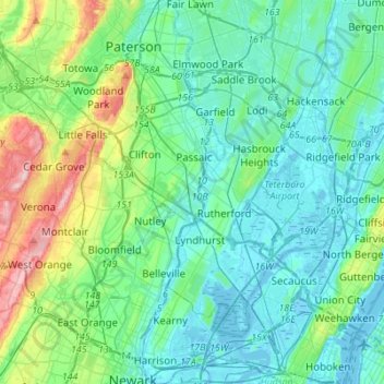
Name: Passaic River topographic map, elevation, terrain.
Average elevation: 42 m
Minimum elevation: -5 m
Maximum elevation: 209 m
Thank you for supporting this site ❤️
Make a donation
Make a donation
Other topographic maps
Click on a map to view its topography, its elevation and its terrain.
Paterson Great Falls National Historical Park
United States > New Jersey > Passaic County > Paterson
Average elevation: 45 m