
Les Augers topographic map
Interactive map
Click on the map to display elevation.
About this map
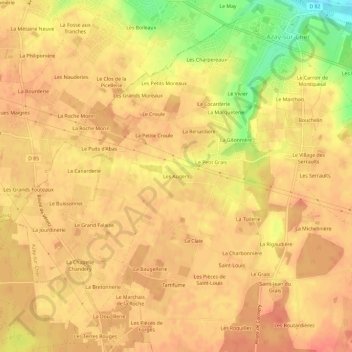
Name: Les Augers topographic map, elevation, terrain.
Average elevation: 87 m
Minimum elevation: 49 m
Maximum elevation: 100 m
Other topographic maps
Click on a map to view its topography, its elevation and its terrain.
Saint-Louis
France > Centre-Val de Loire > Indre-et-Loire > Azay-sur-Cher
Saint-Louis, Azay-sur-Cher, Tours, Indre-et-Loire, Centre-Val de Loire, France métropolitaine, 37270, France
Average elevation: 90 m
Le Bastereau
France > Centre-Val de Loire > Indre-et-Loire > Azay-sur-Cher
Le Bastereau, Azay-sur-Cher, Tours, Indre-et-Loire, Centre-Val de Loire, France métropolitaine, 37270, France
Average elevation: 68 m