
Thank you for supporting this site ❤️
Make a donation
Make a donation
Monte Gennaro topographic map
Click on the map to display elevation.
Thank you for supporting this site ❤️
Make a donation
Make a donation
Monte Gennaro
Monte Gennaro is a peak in the Monti Lucretili, in Lazio, central Italy. It has an elevation of 1,271 metres (4,170 ft) and is the highest peak visible from Rome looking eastwards. It is located in the province of Rome, in the communal territories of Palombara Sabina and San Polo dei Cavalieri.
Thank you for supporting this site ❤️
Make a donation
Make a donation
About this map
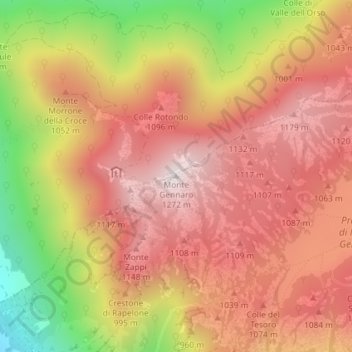
Name: Monte Gennaro topographic map, elevation, terrain.
Average elevation: 930 m
Minimum elevation: 392 m
Maximum elevation: 1,261 m
Thank you for supporting this site ❤️
Make a donation
Make a donation