
Thank you for supporting this site ❤️
Make a donation
Make a donation
Batesville topographic map
Click on the map to display elevation.
Thank you for supporting this site ❤️
Make a donation
Make a donation
About this map
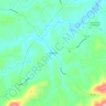
Name: Batesville topographic map, elevation, terrain.
Location: Batesville, Albemarle County, Virginia, 22924, United States (37.97570 -78.74224 38.01570 -78.70224)
Average elevation: 220 m
Minimum elevation: 161 m
Maximum elevation: 403 m
Thank you for supporting this site ❤️
Make a donation
Make a donation
Other topographic maps
Click on a map to view its topography, its elevation and its terrain.
Beaver Creek Park
United States > Virginia > Albemarle County > Charlottesville > Wickham Pond
Average elevation: 185 m
Thank you for supporting this site ❤️
Make a donation
Make a donation
Darden Towe Park
United States > Virginia > Albemarle County > Charlottesville > Franklin
Average elevation: 129 m