
Thank you for supporting this site ❤️
Make a donation
Make a donation
Tai Mo Shan topographic map
Click on the map to display elevation.
Thank you for supporting this site ❤️
Make a donation
Make a donation
Tai Mo Shan
Tai Mo Shan is the highest peak in Hong Kong, with an elevation of 957 metres (3,140 ft) above the Hong Kong Principal Datum [zh], or around 956 metres (3,136 ft) above mean sea level. It is located at approximately the geographical centre of the New Territories.
Thank you for supporting this site ❤️
Make a donation
Make a donation
About this map
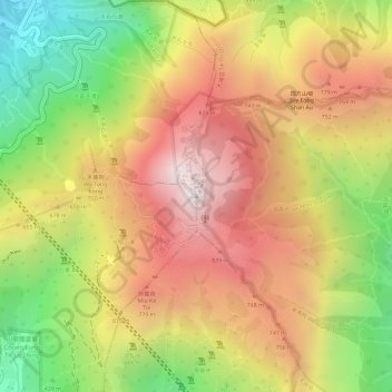
Name: Tai Mo Shan topographic map, elevation, terrain.
Location: Tai Mo Shan, Hong Kong, China (22.41007 114.12455 22.41017 114.12465)
Average elevation: 600 m
Minimum elevation: 147 m
Maximum elevation: 949 m
Thank you for supporting this site ❤️
Make a donation
Make a donation
Other topographic maps
Click on a map to view its topography, its elevation and its terrain.
Thank you for supporting this site ❤️
Make a donation
Make a donation
Thank you for supporting this site ❤️
Make a donation
Make a donation
Thank you for supporting this site ❤️
Make a donation
Make a donation
Thank you for supporting this site ❤️
Make a donation
Make a donation
Thank you for supporting this site ❤️
Make a donation
Make a donation