Fremantle topographic map
Interactive map
Click on the map to display elevation.
About this map
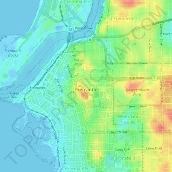
Name: Fremantle topographic map, elevation, terrain.
Location: Fremantle, City of Fremantle, Western Australia, Australia (-32.06394 115.73220 -32.04118 115.77973)
Average elevation: 17 m
Minimum elevation: -10 m
Maximum elevation: 55 m
Other topographic maps
Click on a map to view its topography, its elevation and its terrain.
Fremantle
Australia > Western Australia > City of Fremantle > Fremantle
Fremantle, City of Fremantle, Western Australia, 6959, Australia
Average elevation: 11 m
Port Beach
Australia > Western Australia > City of Fremantle
Port Beach, North Fremantle, City of Fremantle, Western Australia, Australia
Average elevation: 5 m
Beaconsfield
Australia > Western Australia > City of Fremantle
Beaconsfield, City of Fremantle, Western Australia, Australia
Average elevation: 23 m
North Fremantle
Australia > Western Australia > City of Fremantle
North Fremantle, City of Fremantle, Western Australia, 6159, Australia
Average elevation: 12 m
White Gum Valley
Australia > Western Australia > City of Fremantle
White Gum Valley, City of Fremantle, Western Australia, Australia
Average elevation: 30 m
Hilton
Australia > Western Australia > City of Fremantle
Hilton, City of Fremantle, Western Australia, 6183, Australia
Average elevation: 38 m
South Fremantle
Australia > Western Australia > City of Fremantle
South Fremantle, City of Fremantle, Western Australia, 6162, Australia
Average elevation: 9 m
Round House
Australia > Western Australia > City of Fremantle > Fremantle
Round House, 15, Captains Lane, Fremantle, City of Fremantle, Western Australia, 6160, Australia
Average elevation: 4 m