
Savaton topographic map
Interactive map
Click on the map to display elevation.
About this map
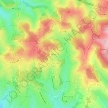
Name: Savaton topographic map, elevation, terrain.
Average elevation: 674 m
Minimum elevation: 529 m
Maximum elevation: 823 m
Other topographic maps
Click on a map to view its topography, its elevation and its terrain.
Saint-Jean
France > Auvergne-Rhône-Alpes > Loire > Sainte-Agathe-en-Donzy > Savaton
Saint-Jean, Savaton, Sainte-Agathe-en-Donzy, Roanne, Loire, Auvergne-Rhône-Alpes, France métropolitaine, 42510, France
Average elevation: 667 m
Sainte-Agathe-en-Donzy
France > Auvergne-Rhône-Alpes > Loire > Sainte-Agathe-en-Donzy
Sainte-Agathe-en-Donzy, Roanne, Loire, Auvergne-Rhône-Alpes, France métropolitaine, 42510, France
Average elevation: 671 m